Home Multi-Country Search About Admin Login
Cenozoic
Cretaceous
Jurassic
Triassic
Permian
Carboniferous
Devonian
Early Paleozoic

Search by
Select Region(s) to search
Hold Ctrl (Windows/Linux) or Command (Mac) to select multiple
Hong Hoi Formation
Click to display on map of the Ancient World at:
Hong Hoi Fm base reconstruction

Hong Hoi Fm


Period: 
Triassic

Age Interval: 
Lower to lower Upper Triassic (Griesbachian-Carnian) 911)


Province: 
Sukhothai Fold Belt

Type Locality and Naming

Type section: Huai Mae Dum to Huai Muang, east of Tha Si village, Mueang Lampang district; Huai Hong Hoi, Dong village, Mae Moh district, Lampang province, west part of the Northern Region of Sukhothai Fold Belt. Parent unit: upper-middle formation in Lampang Gr.

Synonym: หมวดหินฮ่องหอย

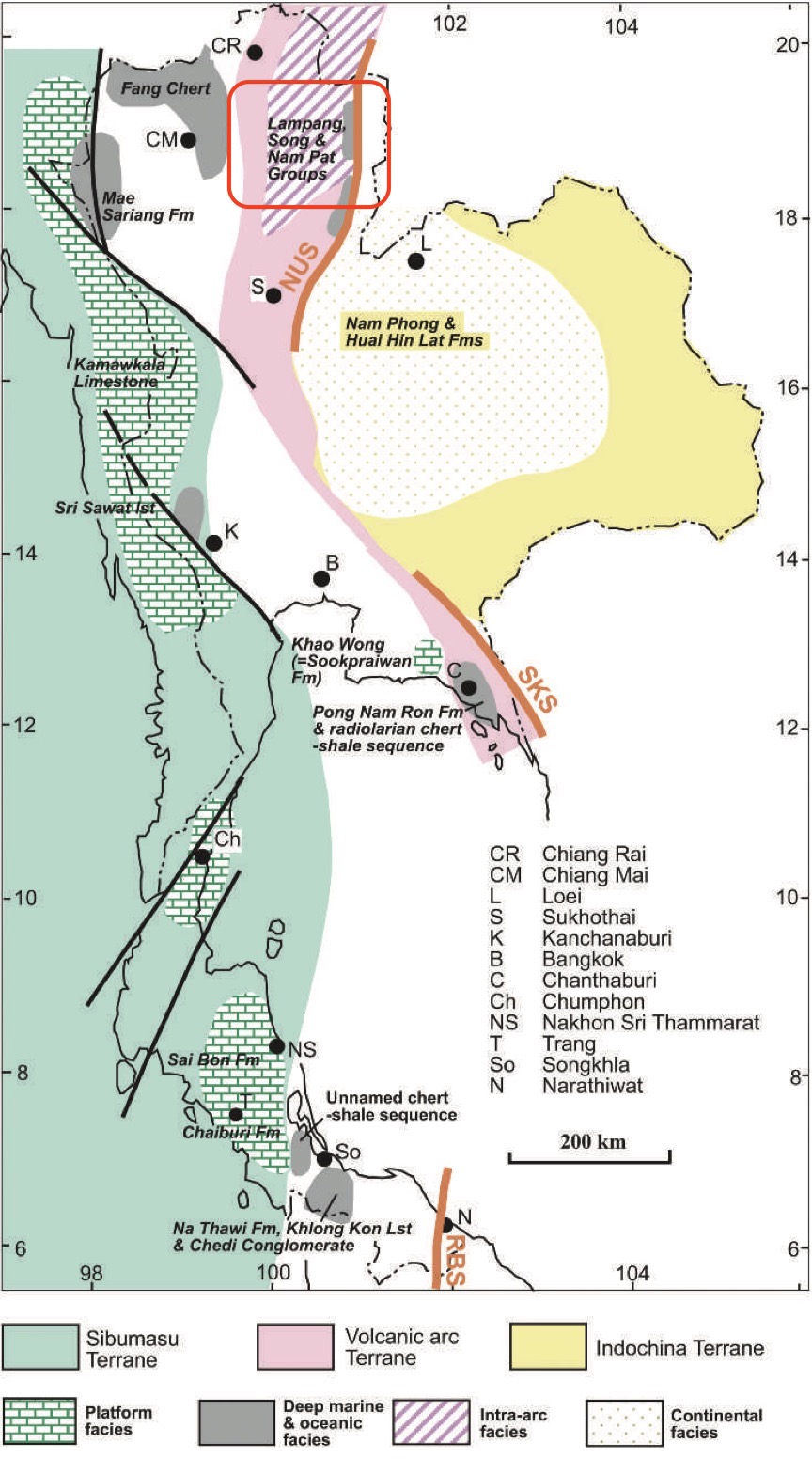
[Figure 1 : Generalized distribution of different Triassic sedimentary environments and some of the more important lithostratigraphic units, and their relations to the terranes. (The geology of Thailand, 2011) page 146]


Lithology and Thickness

Claystone. Greenish-grey shale, mudstone, sandstone, siltstone, conglomerate and minor interbedded argillaceous limestone; Bouma sequences (indicating turbidites) are common. Subdivisions: Chaodumrong and Burrett (1997) subdivide it into 3 members: Tha Si, Mae Dum Sandstone, Huai Muang Members. Thickness: 1,900 m; 700 m at type section at Huai Mae Dum to Huai Muang.

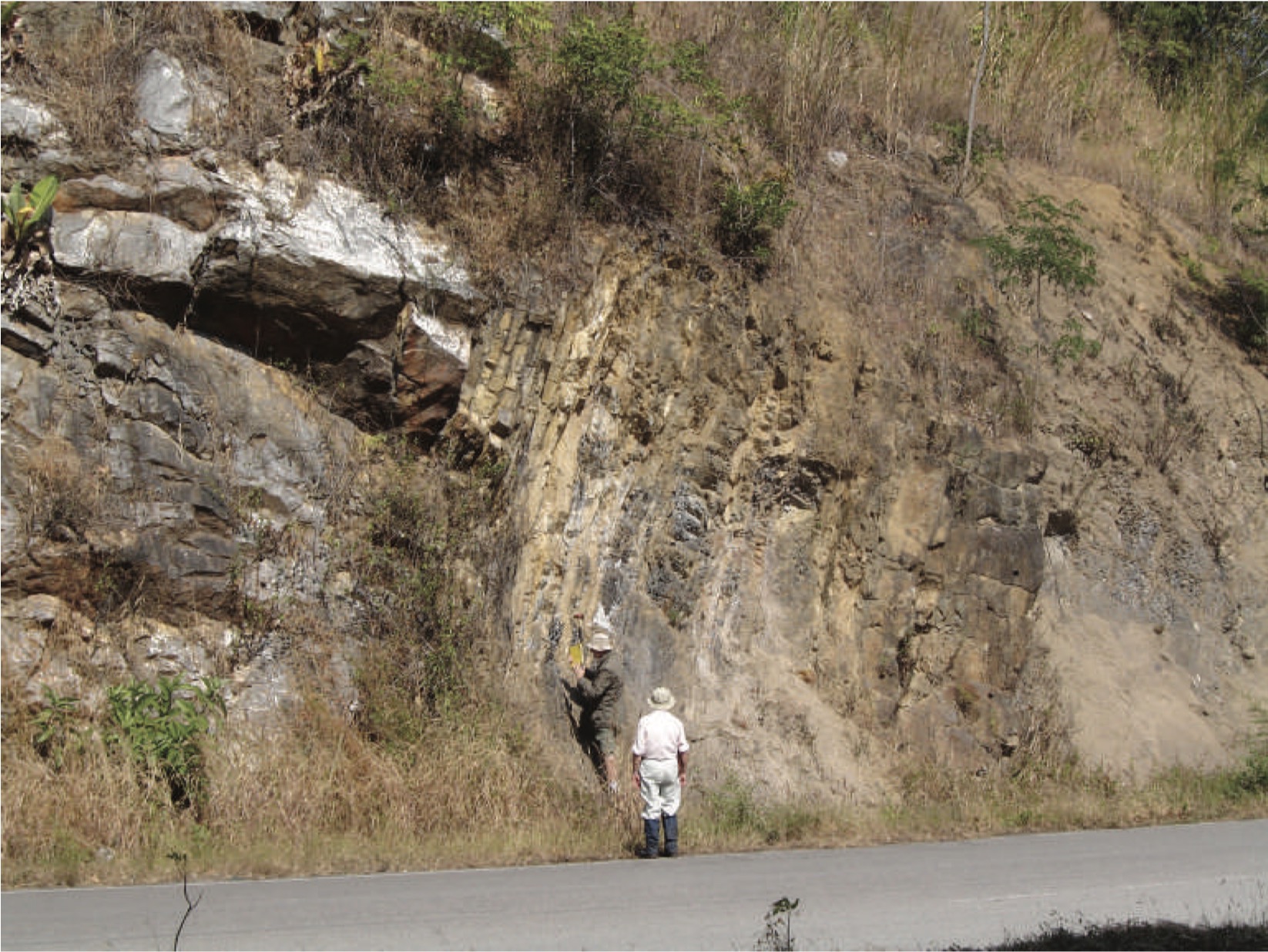
[Figure 2: Northwards view of Hong Hoi Fm overturned to the ESE, comprising conglomerate and pebbly mudstone (extreme right) passing down stratigraphically into arkosic sandstone, then shale and bedded shelly limestone and finally massive limestone of the Pha Kan Fm (on extreme left). Highway 1, Lampang Province, about 18831 0 N, 99849 0 E (photograph courtesy of M. F. Ridd). (The geology of Thailand, 2011) page 139]


Lithology Pattern: 
Sandy claystone


Relationships and Distribution

Lower contact

Pha Kan Fm (conformable)

Upper contact

Doi Long Fm (conformable)

Regional extent

Lampang-Phrae basin, west part of the Northern Region of Sukhothai Fold Belt.

[Figure 3 : Generalized distribution of marine Triassic sedimentary rocks in Thailand (in purple) (modified after Mantajit 1999). (The geology of Thailand, 2011) page 138]


GeoJSON

{"type":"Feature","geometry":{"type":"MultiPolygon","coordinates":[[[[99.59,20.42],[99.77,20.62],[100.02,20.62],[100.29,20.58],[100.56,20.32],[100.65,20.21],[100.86,20.03],[100.99,19.79],[101.06,19.55],[101.01,18.73],[100.44,17.98],[100.3,17.46],[100.3,17.2],[100.08,17.12],[99.93,16.92],[99.9,16.86],[99.64,16.65],[99.6,16.65],[99.3,16.91],[98.84,17.53],[98.8,17.99],[98.9,18.74],[99.29,19.31],[99.59,20.42]]]]}}

Fossils

Ammonoid Joannites sp.; Bivalves and ammonoids


Age 

Ladinian to Early Carnian. Ladinian in Fig. 6.2 of Chonglakmani, C.P., 2011. Detrital zircons date this formation as 238±3 and 239±3 Ma, (Ladinian- Carnian boundary) (Burrett et al).

Age Span: 

    Beginning stage: 
Ladinian

    Fraction up in beginning stage: 
0

    Beginning date (Ma): 
241.50

    Ending stage: 
Carnian

    Fraction up in the ending stage: 
0.0

    Ending date (Ma):  
237.00

Depositional setting

Submarine fan environment


Depositional pattern:  


Additional Information

.


Compiler:  

Wen Du - modified from- Chonglakmani, C.P., 2011, Chapter 6 Triassic in Ridd, M.F., Barber, A.J., and Grow, M.J., editors, The Geology of Thailand, Geol. Soc. of London.;Lexicon of Stratigraphic Names of Thailand of 2013.